Boundary Layer Image
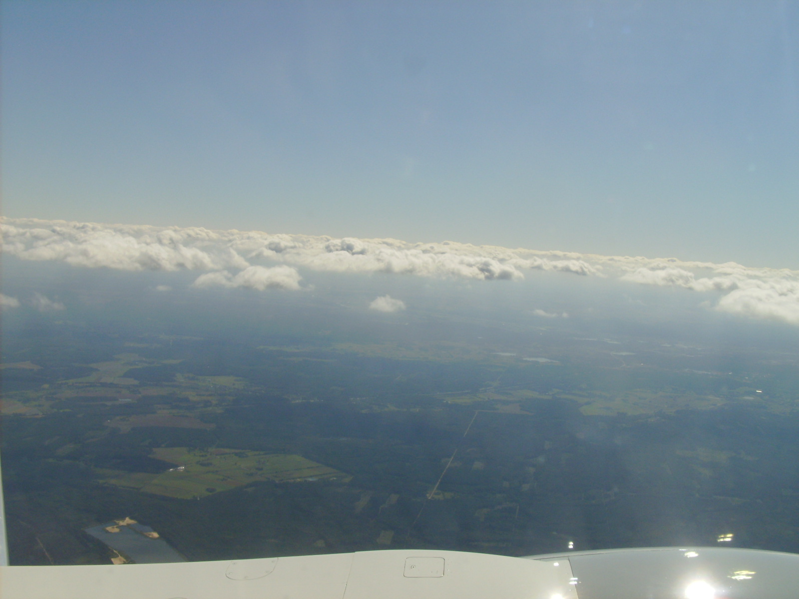
This is an image of the boundary layer, taken near an altitude of about 1 km
over Germany. Air parcels being mixed up from the surface happen to reach
saturation with respect to water vapor near the top of the boundary layer.
The resulting clouds help bring out the top of the boundary layer more
clearly. It's a bit hard to see, but the boundary layer was quite a bit more
hazy (more aerosols) than the cleaner atmosphere above it. The sharp and
well defined boundary layer top suggests the existice of rapid changes in
temperature and humidity at the top of the boundary layer. Polluted regions
sometimes also have very distinct boundary layers.
Discussion of 9.2 in Wallace and Hobbs (not on exam)
This shows a typical eddy (turbulent) heat flux profile for a convective
boundary layer with a surface heat source, growing (entraining) into an
overlying stable layer. Ignore the solid (idealized heat flux) line on
the right hand side. You could define four heights here: zsurf (height
of the surface), zpos (the height up to which the eddy heat flux is
positive), zmin (the height at which the eddy heat flux is minimized),
and zi (the top of the turbulent boundary layer). For the zsurf - zpos
interval, the background stability profile must be unstable (mean theta
decreasing with height) because the eddy heat flux is downgradient (up).
This is the height interval in which there is a buoyant generation of turbulent
TKE from a gravitationally unstable profile (B > 0). For the zpos - zi interval,
the heat flux is negative (down), so the background stratification must be
stable (mean theta increasing with z). The turbulence from below is spreading
into an overlying stable layer, and zi is being pushed up. Note that the
eddy heat flux must be zero at zi by definition. The turbulent heat flux
must go to zero above the BL where the flow is laminar. For z < zmin, the
divergence of the eddy heat flux implies heating. For z between zmin and zi
there is eddy cooling. Turbulence in a stable layer introduces a heating
dipole with a cooling zmin <-> zi layer over a heating zpos <-> zmin layer. This heating
dipole modifies the background theta in such a way as to reduce the stability
and encourage growth in the BL height. Note that in the zpos <-> zi stable layer,
B < 0, so the source of TKE must presumably be M > 0 from wind shear, or
the advection of TKE from below, and this source of TKE is doing work against
both buoyancy (gravity) and dissipation.
Foggy to Stratocumulus Transition (not on exam)
Thin fog (e.g. "morning mist") is easily burned off by the sun soon after
sunrise. In the case of thick fog, the penetration of solar radiation to the
ground becomes very weak, and sunlight becomes unable to burn the fog
away by causing surface heating. This is also partly due to the fact that
the absorption of sunlight by the clean water
fog droplets is very weak. Most of the downward solar radiation at the top
of the fog is therefore
just reflected upward, and is not absorbed either at the ground
or within the fog. What then happens to very thick fog banks? Why aren't they
more common? One reason is the cloud top cooling instability discussed in the
handout. LW radiation is absorbed and emitted very efficiently by water
droplets, so that even a layer just 5 - 10 m thick is effectively opaque in the
LW (even though it may not be opagque in the visible spectrum, i.e. you
can still see through it).
What this means is that the surface stops cooling when fog becomes more
than 5 - 10 m thick. LW radiation is still emitted upward from the surface, but
the upward emission is balanced by a downward LW flux from the fog itself.
(When you walk through thick fog you can feel yourself being bathed in
the thermal radiation of the fog droplets around you, so you don't feel as cold
as on a clear evening ...) However, the top of the fog bank still cools due to
emission of LW radiation, that is only partially balanced by a downward LW flux
from the cold atmosphere above it. Therefore the air at the top of the fog
starts cooling (in technical language due to a LW radiative flux divergence).
Convective overturning will start as soon as an unstable lapse
rate is generated (i.e. PT decreases with height at any point in the fog). This
turbulence does a number of things: (i) it tends to entrain dry air from above
into the fog bank, (ii) It tends to cool the upper part of the fog bank but
warm the lower part of the fog bank (as you go to a constant PT profile in the
fog bank), and (iii) it tends to drive the total water mixing ratio profile to
a constant value. (By total water I mean the [(mass of water vapor) + (mass of
condensed water)]/mass of dry air). All of these factors tend to lift the fog
layer off the ground. If the total water mixing ratio is independent of height,
fog droplets will evaporate first where the temperature is highest, i.e.
closer to the surface. This is the physical origin of the foggy to
stratocumulus transition. It is an example of where convection (turbulent
overturning) is generated by cooling from above rather than the more
common situation of heating from
below. To some extent, all clouds are subject to this radiative destabilization,
and this contributes to the turbulence you sometimes feel when flying through
clouds in airplanes. Of course, in general, it's a weaker source of turbulence
then the turbulence within cumulus clouds, which is driven by surface heating,
and condensational
heating within the plumes.